|
|
|
World War II
At the time of the bombing of Pearl Harbor December 7, 1941 the Treasure Coast was sparsely settled. St. Lucie County, in the heart of that Treasure Coast, had existed since 1905. It encompassed about 600 Square miles of land and 21 miles of ocean coastline. The barrier islands of North and South Hutchinson Islands had only been used to any degree for fishing, "oystering", entertainment and very limited farming. South Hutchinson Island did have limited development after it was accessible by bridge. The islands encompassed about 2,000 acres and include more than 60 miles of ocean and river water front. Also some of the bodies of water seemingly integral to the Indian River carry separate names. One of these is the Blue Hole Creek which is immediately west of the main North Hutchinson Island and east of Queens Cove Peninsula.
The 1940 census shows all of Saint Lucie County with 11,871 people and the largest population center being Fort Pierce with just over 8,000. Indian River County had 8,957 with 3,050 being in Vero Beach. Martin County had 6,295 with Stuart having just over 2,400. While highway US 1 was a paved road, A1A on either North or South Beach did not exist and there were no fully paved east coast/west coast arteries in the middle of the state. What eventually became FL route 70 was mostly a trail, often used by Florida cowboys for moving cattle toward Punta Gordo for shipment to Cuba. The Florida East Coast (FEC) railroad provided north/south rail service for the entire east coast of Florida since the early 1900's. The first train entered Fort Pierce in 1894 and the tracks were extended the whole way to Key West before World War I. Henry Flagler was the principal behind creation of the railroad. Some of its tracks were obtained by acquiring smaller railroads that served parts of the coast. At times it was exclusively a freight line and at other times it also had very popular passenger service. It was heavily used during World War II. By 2013 it was purely a freight line with efforts toward passenger service again in the discussion stage.
World War II caused the Federal government to create new installations along the Atlantic coast. Starting in 1942 German" U-boats" were frequently seen off the coast and were disrupting shipping. 17 ships were attacked along the Treasure Coast with 4 of them near the Hutchinson Islands. There are stories of civilian coastal patrols on the Treasure Coast from Hutchinson Island north to the Cape. Sebastian inlet did not yet exist, so the coastline was continuous. At times horses were used in the beach patrolling. "The Close-in War Off North Hutchinson Island" by Charles Dana Gibson is included later in this history to indicate the closeness of the German threat. The new installations were either for defensive protection along the coast or training for the war effort or both. Several of the new military installations were on the treasure coast. The government initiated efforts to buy, or acquire through condemnation, the lands of both North and South Hutchinson Islands. When those efforts ran into resistance and legal difficulties they leased the lands for the war effort. The islands had been unoccupied except for a Coast Guard Station, a Casino, and a residence on South Beach and the abandoned house of refuge on North Beach. A large complex to train soldiers and sailors for what they would face in invasions by sea was created on these islands.
NAVAL DEMOLITION RESEARCH UNIT
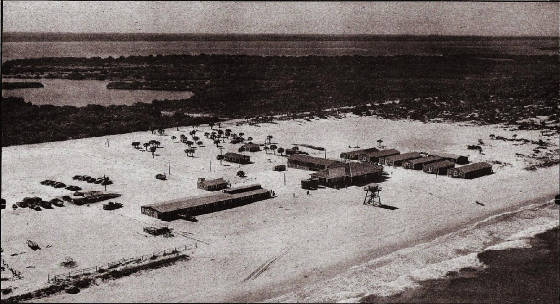
The installation was commissioned January 26, 1943 as the U S Naval Amphibious Training Base. An excellent pictorial coverage of this facility's operation is provided in "World War II in Fort Pierce" by Robert A. Taylor. The base served a vital military function until it was decommissioned in 1946. Tens of thousands of the military went through rigorous training, some estimates as high as 170,000 in total (about 140,000 sailors and soldiers and supporting cast of 30,000). They were generally housed on South Hutchinson in tents or in the local communities around Fort Pierce with the tough invasion training occurring mostly through the troublesome currents of the inlet and on North Hutchinson. Obstacles and entrapments like those anticipated to be encountered on the Normandy beaches in France were created along the beaches of North Hutchinson Island for training purposes. These obstacles were also used for research to find the best way to demolish them during an invasion. A special Joint Army-Navy Experimental and Testing Board (JANET) was created and operated on the island near Round Island Park from an encampment as shown in a subsequent picture. There were tanks and jeeps left on the island after the military operations ceased. These were rounded up and buried between the river and today's A1A. In the early 1970s, the burial area was cleared by cutting and burning, including mangroves, to pave the way for metal detectors to locate the buried equipment so that it could be removed. There are no known remnants of that buried equipment.
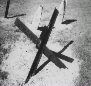
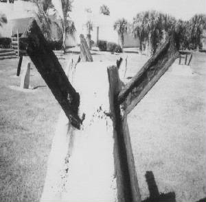
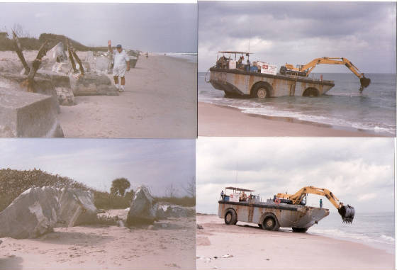
Waters along the coast north of Pepper Park were not cleared of entrapments until turn of the century, long after the beaches were being used for recreational purposes and some people were being injured on hidden obstacles. A display of the actual beach obstacles pulled from the beaches is located at the USDT Seal Museum. It includes hedge hogs, horned scullies, tetrahedrons, and balls. Pictures of some of the beach clearing work of the late 1990's are included on a subsequent page. You can tell the size of the machine involved from the workers on its deck and the fact that the tires on it were 9 feet in diameter. Visitors to Avalon State Park were still warned in 2012 that they may encounter entrapments and another survey of the beaches was planned for 2013. There are also stories of a number of squatters' on the island, some having huts which were torched and some were rounded up and fined in the 1970's. There are no known remnants of that situation.
Many of the soldiers who trained along the Treasure Coast during the war, later returned to visit or to take up residence in this paradise. This helped spur the development of the area so that by 2010 the population on the Treasure Coast had generally increased exponentially. Indian River County had reached 138,000 and St. Lucie County almost 278,000. By 2012 North-beach had about 3,000 residents with the population growth likely to add about 1,200 more if the zoning is unchanged.
|
|